We cannot list our used books online but we are working on this. Please call us at 404-486-0307 for any used title.
Close this alert
Description
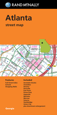
Rand McNally's folded map for Atlanta is a must-have for anyone traveling in and around this part of Georgia, offering unbeatable accuracy and reliability at a great price. Our trusted cartography shows all Interstate, U.S., state, and county highways, along with clearly indicated parks, points of interest, airports, county boundaries, and streets. The easy-to-use legend and detailed index make for quick and easy location of destinations. You'll see why Rand McNally folded maps have been the trusted standard for years.
Regularly updated
Full-color maps
Clearly labeled Interstate, U.S., state, and county highways
Indications of parks, points of interest, airports, county boundaries, schools, shopping malls, downtown & vicinity maps
Easy-to-use legend
Detailed & full street index
Convenient folded size
Coverage Area
Communities Included: Avondale Estates, Chamblee, Decatur, Doraville, East Point, Forest Park, Hapeville, Marietta, Morrow, Smyrna, Stockbridge, Union City plus downtown enlargement
Product Details
Measures 9.5" x 4" and folds out to 40" x 28".